OnTerra Systems Announces That Its MapSavvy WMS & WMTS Services Now Offer Google Maps Imagery
OnTerra Systems’ MapSavvy WMS & WMTS now includes imagery from Google Maps, HERE Maps & Bing Maps
DENVER, March 03, 2026 (GLOBE NEWSWIRE) -- OnTerra Systems today announced that its MapSavvy WMS and WMTS services now have Google Maps layers, along with imagery from Bing Maps and HERE Maps. In addition, the new Google Maps imagery layers are available in both WMS and WMTS service. These new Google layers include:
- Google Satellite – Ortho satellite imagery with Google’s Maps highest resolution and latest updates. This varies by location but includes all satellite imagery available on Google.com/Maps.
- Google Hybrid – Satellite imagery with road data. This includes place names and road names, making it easy to locate an area and visualize imagery.
- Google Roadmap – Road data layer if your use case does not involve the need for satellite imagery. You can use this last as a base street map.
-
Google Terrain – Google terrain layers which combine road data with topographic data to visualize land features like mountains and changes in elevation.
These new Google Maps layers in MapSavvy are available in addition to existing Bing Maps and HERE Technologies layers in the WMS and WMTS services. These different vendor imagery layer options provide a great way to visualize different capture (image acquisition) dates which is useful in before and after visualization for a variety of applications. Applications include drone operation planning, agriculture, research, disaster assessment, architecture & engineering planning, and more.
The addition of Google Maps in MapSavvy provides more up-to-date imagery than many other sources of satellite imagery. As an example, the sample image with this press release shows a view of an urban development site – with a site view from another imagery source where the land is undeveloped, and newer satellite imagery from Google Maps that shows the site is now developed.
Google Maps WMS and WMTS layers from MapSavvy are available at no additional charge for existing MapSavvy customers. Existing MapSavvy users can just refresh their MapSavvy WMS connection to the new imagery layers. Existing customers with older MapSavvy accounts will need to switch to the latest MapSavvy version to get the new Google layers.
Previous MapSavvy customers and trial users can contact OnTerra Systems to have their account re-enabled at https://www.mapsavvy.com/contact/
New customers can sign up for a Free 14-Day Trial by visiting www.MapSavvy.com.
“The team at OnTerra Systems is excited to offer the addition of Google Maps WMS and WMTS services into our MapSavvy offering,” said Erik Lindeman, OnTerra Systems Director of Product Management.
“For many years, MapSavvy has been the WMS of choice for its versatility & affordability. Now, with the addition of 4 new layers in Google Maps WMS and WMTS services, users will have even more options for their satellite imagery needs. OnTerra Systems’ MapSavvy WMS and WMTS now offers the broadest range of imagery options (Google Maps WMS, Bing Maps WMS & HERE Maps) at some of the lowest prices on the market,” he said.
About OnTerra Systems
Founded in 2005, OnTerra Systems is a mapping software company that offers affordable access to traditionally expensive web mapping technologies. OnTerra Systems’ web mapping technology offerings include satellite imagery with MapSavvy.com; advanced, affordable RouteSavvy route planning software, basic and advanced route optimization APIs, and licensing of web map platforms and related consulting and systems integration. For more information, visit: www.OnTerraSystems.com
MEDIA CONTACT:
Courtney DeWinter, DeWinter Marketing & PR Agency – Denver, Colo.
303.572.8180, www.DeWinterMarketingPR.com
A photo accompanying this announcement is available at https://www.globenewswire.com/NewsRoom/AttachmentNg/908718c7-c097-4946-89e6-e4e2514bde45


OnTerra Systems Comparison of Google Satellite Imagery With Other Imagery Sources
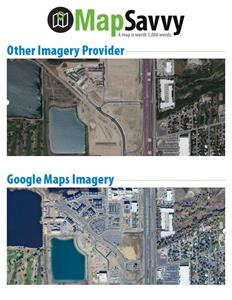
This graphic shows a comparison between an older source of satellite imagery compared to Google Maps imagery - which is now available as part of OnTerra Systems' MapSavvy Web Map Service. MapSavvy offers imagery from Google Maps, HERE Maps & Bing Maps in one affordable Web Map Service. WMS & WMTS formats are both available.
Legal Disclaimer:
EIN Presswire provides this news content "as is" without warranty of any kind. We do not accept any responsibility or liability for the accuracy, content, images, videos, licenses, completeness, legality, or reliability of the information contained in this article. If you have any complaints or copyright issues related to this article, kindly contact the author above.
